

“historical map” of UPSC Geography with a Jharkhand-focused timeline & context.
The UPSC Geography syllabus includes a historical map focusing on Jharkhand, which connects processes under which the Chota Nagpur Plateau, the dense forests and abundant minerals of Jharkhand, and their settlements and economy have taken shape. Due to the geographical location of the Jharkhand plateau, ancient tribal societies remained isolated and preserved their existence during colonial rule. Mineral resources were exploited in Jharkhand. Currently, under the new legal system, land laws have transformed this region, leading to the formation of Chota Nagpur Land Tenacy Act. To address the disparities within Jharkhand, a rebellious leader or movement emerged in the form of Birsa Munda. The rivers, developed mineral resources, and certain assets within Jharkhand, along with its geographical location, reflect the historical changes and distinct characteristics of the region.
1) UPSC Geography — (Core Areas)
GEOGRAPHY (UPSC)
┌────────────────────────┬────────────────────────┐
│ Physical Geography │ Human Geography │
│ │ │
│ – Geomorphology │ – Population │
│ – Climatology │ – Settlements │
│ – Oceanography │ – Economic Geography │
│ – Biogeography │ – Regional Devt │
└────────────────────────┴────────────────────────┘
↓
Application + Mapping + Case Studies
↓
India & States (including Jharkhand)
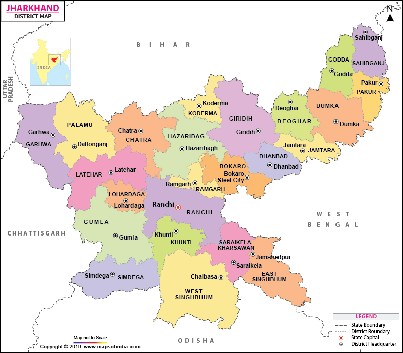
2) Text Map — Jharkhand and its Geo-Historical Regions
NORTH
↑
(Bihar) | Hazaribagh Plateau | (Bihar)
.———————————————.
| 🎯 Jharkhand |
| |
West Bengal — | Ranchi Plateau | — West Bengal
| |
| Chota Nagpur Plateu |
| (Mineral Belt) |
| |
Odisha — | Singhbhum & | — Odisha
| East Singhbhum |
‘———————————————’
↓
SOUTH
Legend:
✔ Ranchi Plateau – Ranchi Central highland where state capital is.
✔ Hazaribagh Plateau – Northern upland region.
✔ Chota Nagpur Plateau – Major geological unit of Jharkhand (minerals, traps).
✔ Singhbhum Region – Iron-ore rich belt.
3) Historical Evolution (Geo-History)
📜 Ancient – Medieval Epoch
- Part of Greater Magadha (early kingdoms in Iron Age India).
- Interacted with ancient routes of Mahajanapadas.
- Dense forests & mineral wealth shaped early settlement patterns.
🏰 Medieval Period
- Ruled by Nagvanshis, Chero rulers, localized chieftains.
- Geography: forest-plateau terrain influenced settlement dispersion & defensive strongholds.
🏛️ Colonial Era (Important for UPSC)
✔ British Territorial Expansion
- Direct annexation of Chota Nagpur (1854).
- Established Chota Nagpur Division under Bengal Presidency.
- Forest laws → extraction of timber & minerals.
🧠 Geographical Significance:
- Plateau + rivers → difficult terrain for British topographic control.
- Rise of tribal resistance (Birsa Munda — 1899–1900).
4) Physical Features (Jharkhand)
Major Rivers
Ganga Basin
↑
North of Jharkhand
Sub-basins:
– Damodar River
– Subarnarekha
– North Koel & South Koel
Plateaus
- Ranchi Plateau
- Hazaribagh Plateau
- Panchet & Rajmahal Hills fringe
Mineral Belt
Chota Nagpur Plateau:
Iron | Coal | Mica | Bauxite | Copper
5) Integrating Jharkhand in Competitive Exam of Geography Topics
| UPSC Topic | Jharkhand Angle (Case-Study) |
| Geomorphology | Plateau processes, laterite, denudation |
| Climatology | Tropical wet-dry; monsoon impact on agriculture |
| River Systems | Damodar as an example of river basin management |
| Soils | Lateritic & alluvial soils — agriculture & land use |
| Mineral Resources | Chota Nagpur mineralization & economic geography |
| Urbanisation | Ranchi, Jamshedpur industrial hubs |
| Population | Tribal demography, migration patterns |
| Regional Development | Backward region classifications, resource-led growth |
6) Quick UPSC Touch Points OF Jharkhand(Revision)
- Birsa Munda & tribal movements — geo-hist link.
- Chota Nagpur Plateau — structure & economic significance.
- Damodar Valley Project — integrated river basin development.
- Forest cover & triballand laws — ecology & policy.
7.main points for Jharkhand geography
1️⃣ Birsa Munda & Tribal Movements — Geo-Historical Link

Birsa Munda’s movement is linked to the Chota Nagpur plateau. He began as a spiritual and political leader among the tribal people. Initially, he acquired his knowledge and guidance from his guru, Pandey Ji. Subsequently, he turned against the missionaries and others who were exploiting the tribal people, opposing them vehemently. He instilled religious fervor and a sense of self-reliance among his followers, drawing upon their connection to the forest and their dependence on it. In this context, he transformed their grievances into a full-fledged rebellion.
2️⃣Chota Nagpur Plateau — Structure & Economic Significance
The geology of Chota Nagpur is a scientific phenomenon where the hard igneous and metamorphic rocks and the settlement patterns influence their shifting cultivation practices. Although rainfall is higher than average, the thin soil and uneven terrain lead to increased leaching of minerals from the ground. The rocks are incredibly rich in minerals such as red iron ore, bauxite, and mica. Jharkhand’s mineral wealth, with its steel plants, mining, and power generation, has made heavy industries in Jamshedpur, Bokaro, and Chaibasa the backbone of the industrial economy of eastern India. This is why the Chota Nagpur Plateau is called the “Ruhr of India.”
3️⃣Damodar Valley Project — Integrated River Basin Development
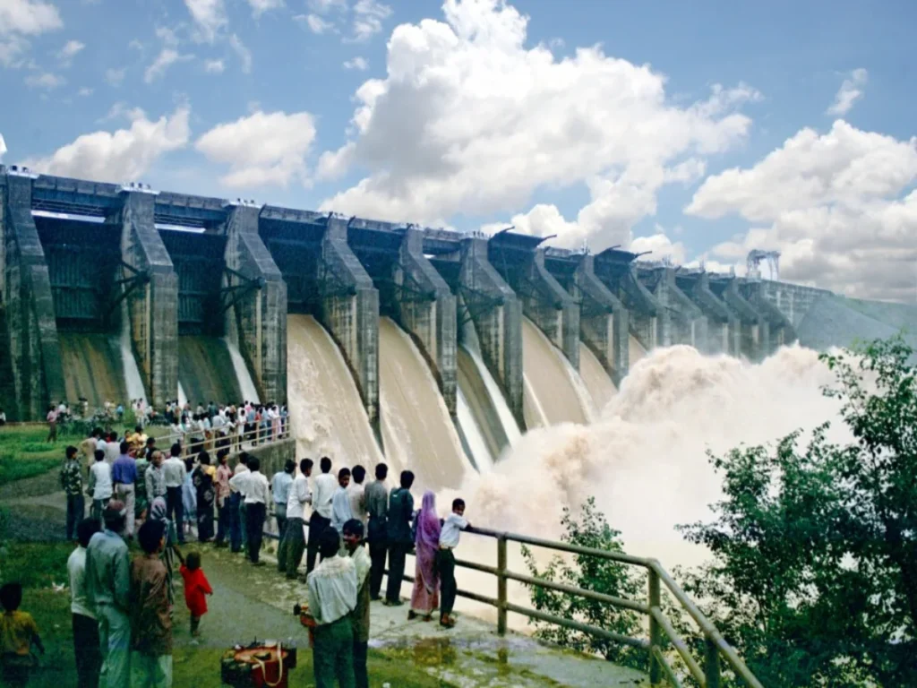
The Damodar Valley Project, a multi-purpose project established by the Constituent Assembly, thus transcending the constitution itself, has the primary objective of controlling floods in West Bengal and Jharkhand. It is the first Indian multi-purpose project that combines flood control with electricity generation and irrigation. The Damodar River, often called the “sorrow of Bengal,” experiences heavy rainfall in its rocky upper reaches. This has led to the construction of dams like Maithon and Panchet, which impound the water to generate hydroelectric power. This project supplied electricity to coal mines and other industries, significantly contributing to industrial growth, and is considered one of India’s mini-Navratna companies, connecting the geography and history of Jharkhand with its development.
4️⃣Forest Cover & Tribal Land Laws — Ecology & Policy
The forests of Jharkhand are not only crucial for ecological balance but also serve as lifelines for tribal communities. Tribal people traditionally reside in the forests, utilising forest products and practising shifting cultivation to sustain their livelihoods. However, operations have restricted tribal access to the forests, leading to the immediate enactment of the Chotanagpur Nagpur Tenancy Act to protect their land rights. In recent times, urban planning policies and development projects have presented new challenges for tribal communities, exacerbating their difficulties. Tribal people strive to maintain a balance between protecting the forests and preserving their rights. This issue affects the relationship between environmental governance and social justice, a topic frequently discussed in resource committee meetings.
